Top Hikes in Yellowstone National Park
Rugged wilderness, majestic peaks, abundant wildlife, and incomparable natural beauty, perhaps no other park is as epic as Yellowstone National Park. Covering over 2 million acres, Yellowstone is home to the world's largest combination of geysers and thermal features, including the iconic Old Faithful. Visitors are likely to see several animals, such as bison, gray wolves, and grizzly bears freely roaming the landscape in their natural habitat. There are more than 900 miles (1,400 kilometers) of hiking trails within the park, from short day hikes along boardwalks to multi-day backpacking trips.
Hiking in Yellowstone National Park
Sure there are unbelievable scenic drives with numerous pullout areas to take in the views of Yellowstone National Park but the best way to see Yellowstone's real beauty is to get out of the car and go for a hike. Spend your time trekking to mountain top vistas, exploring lush meadows, and discovering stunning waterfalls located in Yellowstone's backcountry. It is nearly impossible to hike all the trails within Yellowstone National Park. That's why we've put together a list of the top hikes in Yellowstone to help you get started.
Need help organizing a camping trip? Check out our Camping Tips article.
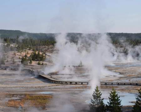
Upper Geyser Basin Loop
- Difficulty: Easy
- Distance: 3 miles (4.8 kilometers) loop trail
Considered the best trail for viewing the iconic hydrothermal features in the park, the Upper Geyser Basin Trail is a series of paved paths and boardwalks that navigate around some of the most predictable geysers in Yellowstone including Old Faithful and Grand Geyser.
The Upper Geyser Basin Trail begins behind the Old Faithful Visitor Center. Start your walk by turning left and heading northwest at the trail junction by Old Faithful Inn. You begin by walking along a bike path leading towards Morning Glory Pool. After about a half-mile (0.8 kilometers), you will pass Castle Geyser, which may be the oldest geyser in Yellowstone. This geyser erupts every 10-12 hours and often reaches heights of 90 feet (27 meters). Continue straight along the trail until you reach Daisy Geyser, which erupts about every 2-3 hours. After roughly 1.3 miles (2.09 kilometers) the trail will come to Morning Glory Pool, a spectacularly colored hot spring of vibrant blue, green, and yellow.
After viewing Morning Glory Pool, head back towards the Visitor Center on the same path as before. Turn left onto a boardwalk at the junction with Grotto Geyser and walk along the east side of the Firehole River. Along this path, you will pass many more picturesque pools and geysers, including Grand Geyser which erupts in powerful bursts every 6-8 hours.
After Grand Geyser the boardwalk will come to a fork at the Lion Geyser group. Turn right at this fork after admiring the wonderful display of colors of Heart Spring. Continue along the boardwalk for a little while longer and then take a right at the next fork leading to a bridge over Firehole River. You walk slightly uphill as the path encircles Old Faithful before returning to the Visitor’s Center to complete the loop.
Note: To add to this hike, consider walking up to Observation Point to take in a different viewpoint of the Upper Geyser Basin and to watch Old Faithful erupt.
Storm Point Trail
- Difficulty: Easy
- Distance: 2.3 miles (3.7 kilometers) round trip
This popular trail leads hikers through forests and grasslands as it makes its way to a strip of dunes and a rock promontory, offering incredible panoramic views of Yellowstone Lake.
The Storm Point Trail begins at a pull-out area right in front of Indian Pond on the East Entrance Road of Yellowstone National Park. The early stages of the trail cross through a grassy meadow where bison can often be seen grazing. Be respectful to the bison and keep your distance, especially in August when rutting season begins.
After crossing the meadow, the trail will come to a fork. This is where the loop around Storm Point begins. Going left at the fork will lead you to a wooden bridge. After crossing the bridge, the scenery opens up offering clear views as the trail leads to the rocky cliffs of Storm Point. An easy climb up the rocks leads to an incredible view of Yellowstone Lake. This is a good spot to enjoy a picnic lunch on a clear day.
Coming down from the rocky cliffs, the trail passes several fumaroles and a strange section of multi-colored clayish rock containing twisted bands of purple and green minerals. After this interesting section, the path turns inland and goes through a small pine forest before returning to the grassy meadows and back to the original fork, thus finishing the loop around Storm Point. Return to the main trail and hike back across the meadow to the parking lot.
Note: Grizzly bears are popular in this area resulting in closures of the trail. Be sure to check about trail restrictions at the ranger’s office before hiking this trail.
Riddle Lake
- Difficulty: Easy
- Distance: 4 miles (6.4 kilometers) round trip
Crossing the Continental Divide, the Riddle Lake Trail meanders through small mountain meadows and forests to the shores of a picturesque little lake. Hikers often view elk in the meadows, birds near the lake, and occasionally spot bears.
The trailhead is right on the continental divide at elevation 8,000 feet, along the South Entrance Road 2.3 miles (3.7 kilometers) south of the turn-off for Grant Village. The single dirt track is well-worn as it passes through tall pine forests and along grassy meadows. The trail is fairly level the entire length to the lake with very minimal elevation gain.
At around 1.5 miles (2.4 kilometers), hikers will get their first glimpse of the lake as the trail crosses two small creeks and then onwards to a lily pad-covered marsh. At just under 2 miles (3.2 kilometers), hikers will reach the lake. It appears as though the trail ends here, but if you continue following a path through the forest on the east side of the lake you will reach a small beach at the northeast end of the lake. This is a great spot to relax and take in the views before returning on the same path back to the trailhead.
Note: This trail is closed each year from the end of April through mid-July as it is located in a bear management area. It is highly recommended to hike in a group and make noise while hiking this trail to alert wildlife of your presence.
Trout Lake
- Difficulty: Easy to moderate
- Distance: 1.3 miles (2.09 kilometers) loop trail
This is a short and steep lollipop hike to a beautiful mountain lake that offers plenty of opportunities to see wildlife.
The Trout Lake Trailhead can be found at a small pullout about 1.5 miles (2.4 kilometers) south of Pebble Creek Campground on the Northeast Entrance Road. After leaving the parking area, the trail begins a moderate climb through Douglas-fir forest. Over the first half-mile (0.8 kilometers), the trail will gain roughly 200 feet (60 meters) along a ridgeline before leveling out. Shortly after leveling out, the trail will descend to the shoreline of the lake.
At the junction near the shoreline, you can choose to hike in either direction. The loop around the lake is roughly a half-mile (0.8 kilometers). Hikers will cross a footbridge that crosses over a small outlet stream near a tiny waterfall and another inlet stream that feeds the lake. Along the southern end of the lake hikers will reach a short side trail that leads up to a hill that overlooks the Soda Butte Creek valley and surrounding mountains. It’s worth the small trip to gain a better viewpoint of the lake and to look for bison herds grazing in the area. After completing the loop around the lake, return on the main path and retrace your steps back to the parking area to complete the hike.
Note: Trout Lake is a great spot for fishing and home to several ospreys.
Fairy Falls Trail
- Difficulty: Easy to moderate
- Distance: 5 miles (8 kilometers) round trip
This pleasant hike leads through the wilderness to the 200 foot (60 meters) Fairy Falls, one of Yellowstone’s most astonishing waterfalls.
The Fairy Falls hike is located 6 miles (9.6 kilometers) north of Old Faithful near the Midway Geyser Basin. The trail begins from the Fountain Flat Drive, a 6.4 km bike path connecting the end of Fountain Drive Flat Drive to the Fairy Falls parking lot.
Start your hike by crossing the Firehole River on an old bridge and following the dirt road. At around a half-mile (1 kilometer), you will find a small spur trail leading to an overlook of Grand Prismatic Spring. This quick side trip is well worth it for the view. After snapping photos of Grand Prismatic, return to the main dirt road. At the 1 mile (1.6 kilometers) mark from the bridge, you will reach the official trailhead of Fairy Falls Trail, located on the left.
After turning left onto the Fairy Falls Trail, you will enter a bristlecone pine forest. The trail remains flat and is well-marked. The trail continues through this forest of pine for about 1.5 miles (2.4 kilometers) until it reaches the base of Fairy Falls.
Brink of the Lower Falls
- Difficulty: Moderate (though the steep climb back up can be challenging)
- Distance: 1 mile (1.6 kilometers) out and back
You won’t want to forget your camera when hiking this trail as you descend to a viewpoint over the Lower Yellowstone Falls and out into the Grand Canyon of Yellowstone.
The trailhead is located at the Brink of the Lower Falls parking area near Canyon Village, a popular area of the park. The trail will immediately begin to descend along switchbacks through a mostly forested area. Though a majority of the trail is paved, the steep incline adds to the challenge, and be careful as there are multiple steep drop-offs down to the canyon below. After walking approximately a half-mile (0.8 kilometers) you will reach an observation deck, located right at the crest of the Lower Yellowstone Falls.
Take your time walking back up the steep trail to the parking lot and be sure to take in the views along the way.
Note: While in this area, take the short walk to Artist Point for one of the most scenic viewpoints in all of Yellowstone National Park.

Interesting in hiking at other National Parks?
- Top Hikes in Yosemite National Park
- Top Hikes in Bryce Canyon National Park
- Top Hikes in Great Smoky Mountains National Park
- Top Hikes in Zion National Park
- Top Hikes in Acadia National Park
Lamar River Trail
- Difficulty: Moderate
- Distance: 5 miles (8 kilometers) round trip
The Lamar River Trail takes hikers into one of the more scenic parts of Yellowstone as it meanders through meadows, over rolling hills, and into the Lamar Valley, one of the best places to observe wildlife.
The hike begins at the Lamar River Trailhead, which is also referred to as the Soda Butte Trailhead. The parking area is located roughly 15 miles east of Tower Junction on Northeast Entrance Road.
Shortly after starting from the trailhead, hikers will need to cross a bridge over Soda Butte Creek and head southwest. This section of the trail travels through sagebrush meadows as it makes its way to the junction of the Lamar River Stock Trail, located 1.1 miles (1.7 kilometers) from the bridge. Be sure to keep your eye out for bison herds in this area.
Continue straight at the junction to stay on the main Lamar River Trail. At 1.5 miles (2.4 kilometers), you will come to the junction with Specimen Ridge Trail, a popular backpacking route. Turn right at the junction, joining together with the Specimen Ridge Trail. After about 1 mile (1.6 kilometers) the trail will lead to the Lamar River. This is a great place to hang out and relax, keeping an eye out for wildlife grazing along the river banks, or cast a fishing line to catch a Yellowstone cutthroat trout.
After you spent time enjoying the quietness around the river, simply retrace your steps back to the trailhead.
Note: This hike can be extended by hiking further along the Specimen Ridge Trail or one can opt to hike towards Cache Creek by turning left when coming to the junction of the Specimen Ridge Trail.
Bunsen Peak
- Difficulty: Moderate
- Distance: 4.4 miles (7.08 kilometers) round trip
This relatively short hike provides impressive views of Mammoth Hot Springs and the Yellowstone River Valley while viewing the effects of the 1988 fires.
The Bunsen Peak trailhead can be found just south of the golden gate at the gravel parking lot along the Mammoth to Norris road, about 5 miles (8 kilometers) south of Mammoth. The trail starts on the north side of a dirt road just past the barricade.
The trail begins to climb as soon as you begin hiking. Shortly after starting the hike, you will come to a junction. Take the left path that leads to Bunsen Peak. At just under a mile (1.6 kilometers) from the parking lot, the trail will begin climbing the main mountain. There are a series of gentle switchbacks that lead in and out of forested areas. Along the trail, multiple open areas provide hikers with views of the Gallatin Mountain Range and Swan Lake Flats. At roughly 1.5 miles (2.4 kilometers), the trail will open up to view Mammoth Hot Springs and a rock formation known as Cathedral Rock.
At just over 2 miles (3.2 kilometers), the trail reaches a radio cabin. Though many think this is the summit, the real summit is another 0.2 miles (30+ meters) where you will find four concrete footings that once supported a fire lookout tower. From both locations, hikers will be rewarded with panoramic views from atop an ancient volcanic cone.
Return to the trailhead by retracing your steps along the same trail.
Mount Washburn
- Difficulty: Moderate
- Distance: 7 miles (11.2 kilometers) round trip
One of Yellowstone’s classic day hikes, this trail takes hikers to the summit of the 10,243-foot (3,122 meters) Mount Washburn.
Mount Washburn may be approached from either Chittenden Road (north) or Dunraven Pass (south). The northern path is a little shorter and steeper, following a long, treeless ridge for all its 2.25 miles (3.6 kilometers). The southern route, 3 miles (4.8 kilometers) in length, is more winding, switchbacking up the hillside through a mix of forest, meadows, and rocky outcrops. Since the southern route, which starts at Dunraven Pass, is known to be more scenic, we’ll describe that route below.
Beginning on an old road from Dunraven Pass, the trail begins climbing fairly gently up an open, grassy hillside. As the trail climbs higher, it turns into a forested area and then begins to twist and turn its way up the mountain. As the trail gains elevation, views of the Grand Canyon of Yellowstone and the open meadows of Hayden Valley will become more visible.
Eventually, you will be able to see the fire tower that is located on top of Mount Washburn. The trail navigates around the mountain below the fire tower before making the final push to the summit, just about 3.5 miles from the trailhead.
The radio tower has a few interpretive exhibits and restrooms on the lower level and an enclosed, open-air observation deck on the middle level. The third floor, closed to the public, contains a ranger’s residence. On a clear day at the top of the summit, one can see the mountain ranges of the Tetons and the Absarokas.
After taking in the views and signing the summit book, return along the same trail you climbed up to complete the hike.
Cascade Lake Trail to Observation Peak
- Difficulty: Moderate to challenging
- Distance: 10 miles (16 kilometers) round trip
This hike combines walking among beautiful meadows to a small scenic lake and then climbing up an alpine ridge to an incredible 360-degree panoramic view to the northern section of Yellowstone National Park.
This trail can be approached from a few different directions, but the most pleasant starting point is from the Cascade Lake Trailhead, 1 mile (1.6 kilometers) north of Canyon Junction in Yellowstone Park.
From the trailhead, follow the Cascade Lake Trail as it cuts into a stand of lodgepole pines before breaking out to forest-lined meadows and bushy grassland. The trail leads towards the west, running along the edge of the meadow and crossing over a few small streams, then eventually coming to the main Cascade Creek. At 1.2 miles (1.9 kilometers), the trail meets the junction with the Cascade Creek Trail. Turn right at the junction and continue hiking another mile (1.6 kilometers) until you reach Cascade Lake, which is surrounded by meadows and tucked underneath Observation Point.
The Observation Point Trail breaks off on the north side of the lake, just before reaching the actual lake. You will notice the trail immediately begins to ascend along the ridge through clumps of woodland and then into open hillsides. During the springtime, hikers will be rewarded with wonderful displays of wildflowers throughout this section.
The trail continues to follow the ridgeline through an area of burnt woodland. After a long straight section of trail, you will hike up a series of switchbacks making the final incline to the summit. There is an old, wooden lookout tower perched on top of the summit. From the summit of Observation Peak, you will be able to see Cascade Lake below, the Grand Canyon of Yellowstone to the east, and the Gallatin Range in the distance to the west.
Retrace your steps down to the base of Observation Point, returning to Cascade Lake, and then hike the same trail back to the trailhead to complete the hike.
Note: The meadows leading to Cascade Lake can be wet and muddy early in the spring after the snow melts. Mosquitos are present in this area as well.

Avalanche Peak Trail
- Difficulty: Strenuous
- Distance: 4.7 miles (7.5 kilometers) round trip
One of the best options to get above 10,000 feet (3,000 meters) in Yellowstone, the climb up Avalanche Peak is not for the faint of heart. Though the view from the top will reward hikers with unforgettable views of Yellowstone’s magnificent beauty.
The Avalanche Peak Trailhead can be found just west of Eleanor Lake on the East Entrance Road about 8 miles west of the entrance gate. Look for a small pullout on the south side of the road. The trail begins across the road from the parking lot.
The trail immediately enters the forest and begins to climb without any help of switchbacks or flat areas. About 0.7 miles (1.1 kilometers), the trail dips slightly into a meadow, and hikers will be able to see views of Top Notch Peak to the south. After crossing the meadow the trail returns to the forest. During the section of the trail, you will several areas where the trees have been flattened by powerful snow avalanches, thus giving the peak its name.
At the 1.3-mile (2.09 kilometers) mark the trail levels out and you are at the foot of a huge amphitheater-like bowl, the top of which is Avalanche Peak. Follow the trail to your left as it climbs through open talus slopes and makes its final ascent of the peak along the mountain's southern ridge. There are a few sections along this stretch where the path becomes fairly narrow, with some exposure to steep drop-offs. As long as you’re careful you shouldn’t have any problems here. However, if you notice the threat of bad weather, you may not want to proceed past this point.
At 1.7 miles (2.7 kilometers), the trail reaches another meadow just below the summit. You will be able to see the trail as it follows the ridgeline. Follow this trail as it ascends to the summit at just over 2 miles (3.2 kilometers) from the trailhead. There are technically two humps on top of the mountain with one being slightly taller than the other. From both humps the views of the rugged Absaroka Mountains surround you and the magnificent Yellowstone Lake lies out to the west. On a super clear day, you may even be able to see the Grand Tetons in the southwest.
Note: The upper sections of this trail can be snow-covered until early July. Please check trail conditions before hiking to the summit of Avalanche Peak.
Sky Rim Trail
- Difficulty: Strenuous
- Distance: 19 miles (30.5 kilometers) loop
This high-alpine loop trail is one of the more challenging yet rewarding hikes in all of Yellowstone. Tucked away in the remote northwest corner of the park, the trail contours along exposed ridgelines offering unbelievable mountain vistas.
The hike begins at the Dailey Creek Trailhead, located along Highway 191, about 30 miles (50 kilometers) north of West Yellowstone. The beginning of the trail follows along the tiny Dailey Creek as it meanders through grassy meadows on relatively flat terrain. At just under 2 miles (3.2 kilometers) the trail passes the junction of the Black Butte-Dailey Creek Cutoff Trail. Make note of this area as it is part of the return trail on the loop.
Staying to the left at this junction, follow signs for the Sky Rim Trail. Continuing on the main trail, you will come to a backcountry campground and a small spur trail on the left at 2.8 miles (4.5 kilometers). The trail will slowly start to gain elevation as you begin to approach the rim and eventually opens up onto a dirt-covered ridge at the 3.6 miles (5.8 kilometers) mark.
From here the trail quickly gains elevation as it climbs up to Dailey Pass, reached at 5 miles (8 kilometers) from the trailhead. This is where the jaw-dropping views become a reality as you walk along the pass the straddles Yellowstone National Park and Custer Gallatin National Forest. At 5.7 miles (9.2 kilometers), turn right to join the junction with the Tom Minor Divide Trail.
Now the trail will go through a series of ups and downs, with a few big hills to climb, on the way to Big Horn Peak. Be sure to keep an eye out for the trail markers as part of this section can sometimes be difficult to navigate. However, simply continue to saddle the ridge and you should not get lost. Along this section, you should be able to see views of fossilized trees which are part of the Gallatin Petrified Forest.
At 10.4 miles (16.7 kilometers) the trial passes the Black Butte Trail junction. You will need to turn right here to start your hike down back to the trailhead but first go straight to reach the summit of the 9,930 foot (3.026 meters) Big Horn Peak. This summit is only 0.3 (400 meters) from the junction. The views from the peak are majestic though be careful navigating the final rocky sections along the ridge.
After taking the views, return to the junction with the Black Butte Trail and turn left heading down into the meadows below. This section descends quickly and can be very steep at times. Walk slowly and be careful not to lose your footing. Keeping the rock cliffs on your left will help with not losing the trail as well.
At around 15 miles (24 kilometers) the Black Butte-Dailey Creek Cutoff Trail is reached. Turn right at this junction, following the Cutoff Trail as it climbs uphill to an old ranger cabin. After passing the cabin, the trail will descend and rejoin the Dailey Creek Trail at around 17 miles (27 kilometers). Turn left here and hike the remaining 2 miles (3.2 kilometers) back to the Dailey Creek Trailhead.
Note: This is one of the most challenging hikes in all of Yellowstone that tires out some of the most experienced hikers. Be aware that there is no reliable water for the majority of the hike and hikers are exposed to weather conditions while hiking along the ridgeline.
Need new hiking boots? Read out Hiking Boots Guide before heading to the store.
Now that we’ve highlighted the must-do hikes when visiting Yellowstone National Park, let’s review the essentials to bring along with you when hitting the trails.
Hiking Essentials
- Map: Remember, your smartphone may not have reception at every trailhead. So print out a map of the area and know the important junctions on the trail. Alternately, ask for a map at the park entrance, or download an offline version of the trail map through an app like AllTrails.
- Water: The amount depends on the climate where you are hiking, but a good rule of thumb is 1 liter (32 ounces) for every two hours of activity.
- Snacks: Always bring a snack, just in case your hike goes longer than planned. Trail mix, granola bars, dried fruit. Keep it nutritious.
- Sun Protection: Apply a layer of sunscreen on your skin before heading out for a hike, even if it’s a cloudy day. Consider wearing a hat or sunglasses to minimize exposure to the sun. You can wear SPF protective clothing as well.
- Headlamp: Whether for an overnight or day hike, bringing along a headlamp is an essential safety must-have. These are small, lightweight devices that fit easily into any bag. You never know when you might need it, and if you do, you’ll be happy to have one.
- Rain gear: Ultralight rain jackets pack down small and can easily fit into your bag. Rainstorms can pop out of nowhere and it’s best to be dry when out in nature.
- First aid kit: Your first aid kit doesn’t need to be big. But make sure you have the basics: bandaids, alcohol wipes, waterproof matches, moleskin, burn treatment, and duct tape.
Okay, now that we’ve got our hiking safety taken care of, head out and explore the top hikes in Yellowstone National Park.
Worried about figuring out all the logistics when exploring Yellowstone National Park. Join like-minded travelers of Under30Experiences on our Grand Teton & Yellowstone trip.
Additional articles related to camping and hiking:
- Camping Menu: Easy Meal Ideas for Every Camping Trip
- Essential Camping Gear Checklist
- Top 20 Camping Destinations for Your First Trip
For more great travel guides and all of our best content make sure you are signed up to our travel blog newsletter.


.webp)
.webp)
.webp)